
Putnam's Scientific Report
George Putnam published his magnetic observations from the 1986 Greenland Expedition in the Journal of Geophysical Reseach, Terrestrial Magnetism. According to his journal, this magnetic data was "...for [the] purpose of studying the condition of ice in Hudson Strait, etc., with respect to navigation." For each station, Putnam recorded latitude, longitude, the total days and dates of observation, angles of declination, and measurements of magnetic force. A summary of his findings from the paper are provided in the table below.
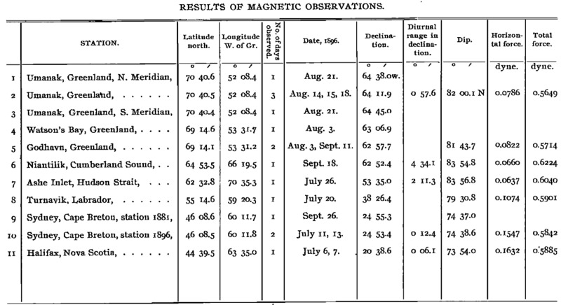
Explination of Putnam's Magnetic Results
"The principle object in our landing was to make the magnetic and pendulum observations. During the day set up magnetic, pendulum and astronomical apparatus... and made sun observations"
G. R. Putnam
Putnam's magnetic observations gathered both important navigational data for expeditions to come, and scientific clues and information in the interests of the U.S. Geodetic Survey, for which Putnam was working. Polar regions are often sites of magnetic anomalies that can provide clues to the geologic structure of Earth below the visible surface. Putnam even recorded one such polar magnetic anomaly in Niantilik on September 18th. The diurnal range swings above 4 degrees, indicitive of a magnetic storm or other form of disturbance. Upon his return from Greenland, Putnam consulted scientists in Washington to confirm this anomaly:
"An inspection of the magnetograms of he U.S. Naval Observatory at Washington indicates an unusual magnetic disturbance on that date."
G.R. Putnam, Results of Magnetic Observations on the Greenland Expedition of 1986
Putnam's pendulum observations (listed below) were used to determine the relative force of gravity at the stations. Winds coming from the Greenland ice sheet can create strong gales which are driven by gravity. Gravitational observations can also be used in monitoring mass distribution and transportation of sea ice, as mentioned by Putnam above. Such information is crucial when determining navigation routes for ships and planning for trips onto sea ice or the mainland of Greenland.

Sources:
Magnetic and Pendulum Observations. (1898), Nature, 57, 347–348. https://doi.org/10.1038/057347a0
Putnam, G. R. (1897), Results of magnetic observations on the Greenland Expedition of 1896, Terr. Magn., 2(1), 32–34, doi:10.1029/TM002i001p00032.
https://www.usgs.gov/science/faqs/planetary-science