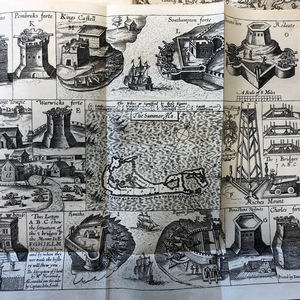
Map of the Summer Isles from The Generall Historie of Virginia, New England, and the Summer Isles.
Item
-
Identifier
-
Brillante 3
-
Title
-
Map of the Summer Isles from The Generall Historie of Virginia, New England, and the Summer Isles.
-
Description
-
This is a map depicting Bermuda. It is contained in the same book that contains the Map of Virginia as depicted by Captain John Smith. This map shows many of the forts and structures, as well as a small layout of the town. This is significant not only because of the fact that it shows the major structures on the island, but the importance placed on the illustrations of the forts helps to understand what was most important to the English. These illustrations are evidence of how crucial security was to the English. They were trying to ensure their safety because they were worried about potential Spanish attacks. This helps us to contextualize the cautious and protective nature of the English during their settlement of Bermuda. (Brillante)
-
Creator
-
M. Norwood contracted by John Smith
-
Date Created
-
1624
-
Publisher
-
London: Sparkes, 1624
-
Bibliographic Citation
-
Smith, John. The Generall Historie of Virginia, New England, and the Summer Isles : with the Names of the Adventurers, Planters, and Governours from Their First Beginning, Ano: 1584, to This Present 1624. With the Procedings of Those Severall Colonies and the Accidents That Befell Them in All Their Journyes and Discoveries. Also the Maps and Descriptions of All Those Countryes, Their Commodities, People, Government, Customes, and Religion yet Knowne. Divided into Sixe Bookes London: Printed by I. D. and I. H. for Michael Sparkes, 1624.
-
https://search.library.dartmouth.edu/discovery/fulldisplay?docid=alma991020593239705706&context=L&vid=01DCL_INST:01DCL&lang=en

 Brillante.3.jpeg